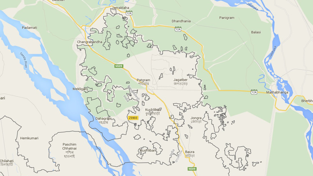
Prior to the 2015 land exchange agreement between India and Bangladesh, the international border in the Cooch Behar region was a mess to say the least. It was dotted with a bewildering mix of territories belonging to each country but completely surrounded by the other, known as enclaves. India had 102 pieces of land within Bangladesh, while Bangladesh had 71 within India. Adding to this intrigue were the 21 Bangladeshi counter-enclaves nestled inside Indian enclaves, and the chaos reached its peak with Dahala Khagrabari, the only counter-counter enclave in the world at that time.
For geography enthusiasts, the simplification of this extraordinary border scenario may be disappointing, but fear not, as the internal state borders of India offer their own intricate tapestry. In this article, we will explore the enclaves of various Indian states, most of which remain obscure and are seldom mentioned outside the detailed maps provided by the Survey of India.
Puducherry

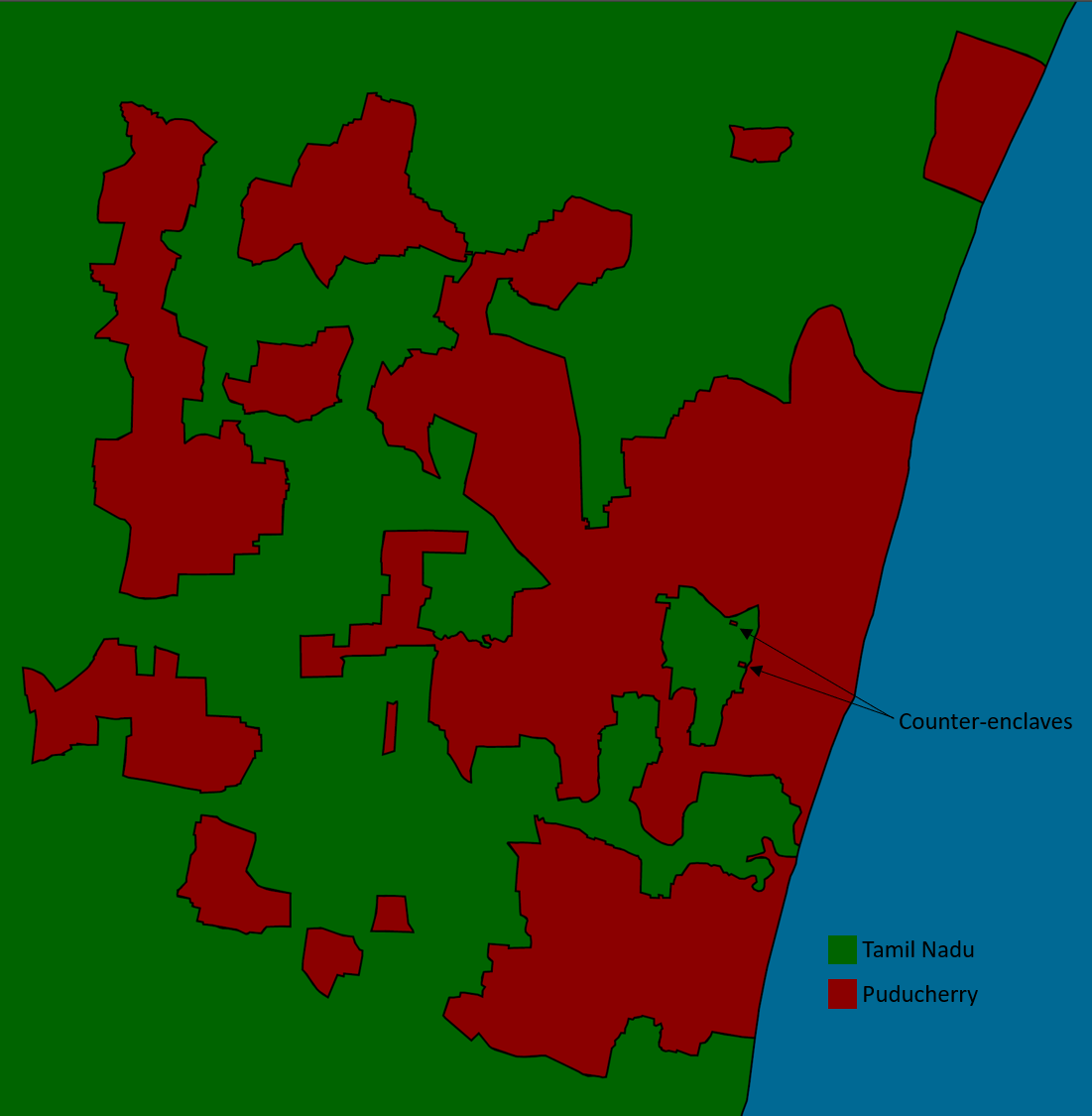
We can’t help but start with the peculiar case of Puducherry. Often mistaken as just the city of Puducherry, this Union Territory actually encompasses four geographically distant districts: Puducherry, Karaikal, Mahé, and Yanam. The first two lie on the Tamil Nadu coast, whereas Mahé is situated on the Kerala coast. Yanam is an enclave nestled within Andhra Pradesh, albeit located close to the coast.
But wait, there’s more! The Puducherry district itself is made up of 12 non-contiguous parts. Nine of these parts are enclaves completely surrounded by the neighboring state of Tamil Nadu. And if that wasn’t interesting enough, Tamil Nadu also has an enclave within Puducherry. And guess what? That enclave also contains two counter-enclaves!
Maintaining this tradition of complexity, Karaikal district holds four enclaves within Tamil Nadu. On the flip side, Tamil Nadu itself has two enclaves within the boundaries of Karaikal. Meanwhile, the Mahé district also has an enclave within Kerala.
It’s worth pondering why we continue to hold onto colonial baggage like these strange borders, but that’s a topic for another day.
Madhya Pradesh

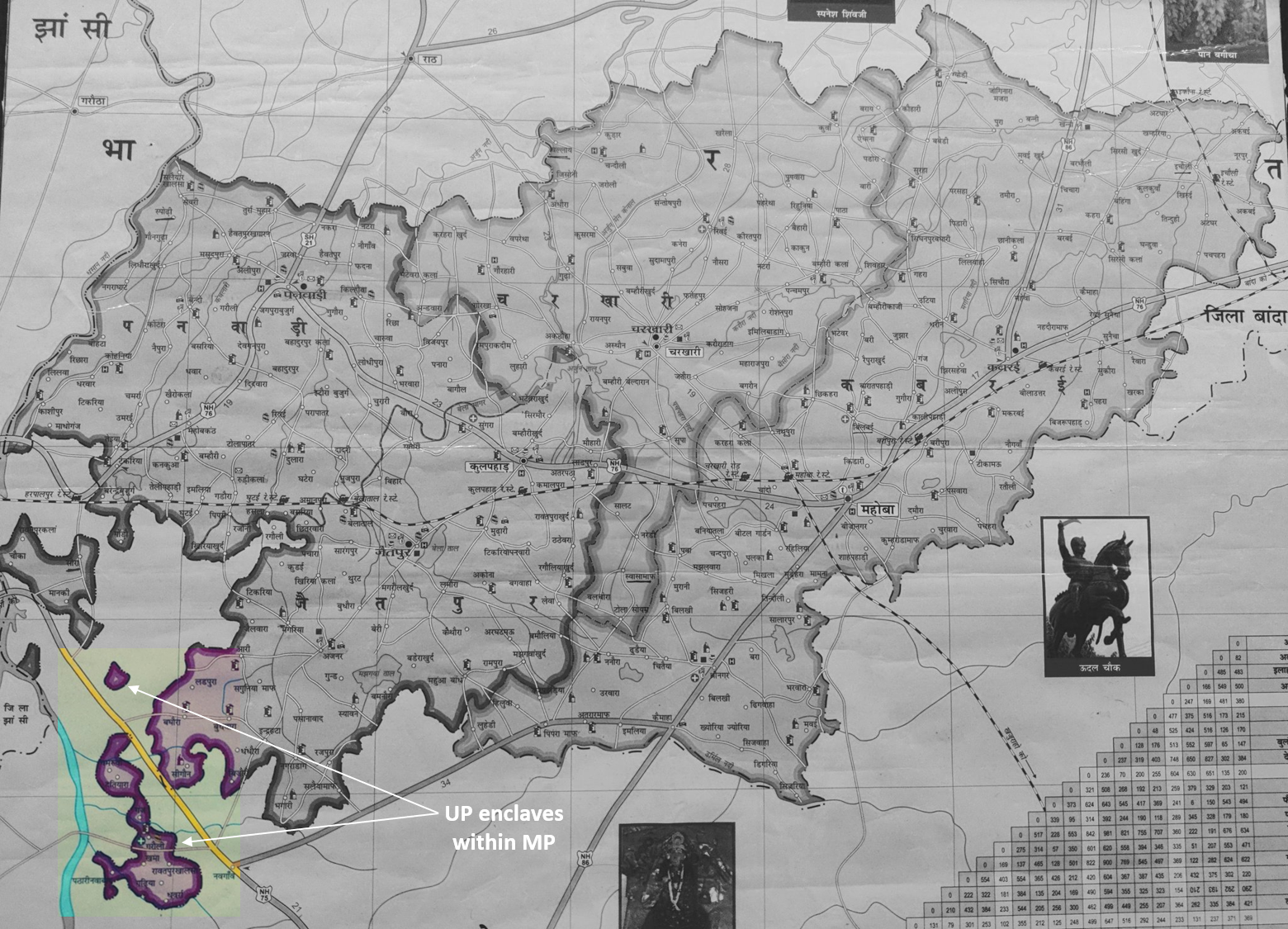
Let’s journey into the heart of India, where fascinating border scenarios unfold between Madhya Pradesh and its neighboring states. To the north lies Uttar Pradesh, which harbors two enclaves within Madhya Pradesh as part of its Mahoba district. The border between the two states features Uttar Pradesh’s very own “Siliguri Corridor.” This narrow strip of land connects the Lalitpur district of Uttar Pradesh with the rest of the state. Interestingly, nestled within this corridor is Karkigarh, an uninhabited island in the Betwa River—an enclave belonging to Madhya Pradesh. Interestingly, this island has some history from the British era associated with it. Originally an isolated pocket of the Orchha state within the United Provinces, its enclave status deceived the government surveyors of that time, who believed it to be a British possession. Consequently, the British PWD department decided to submerge the island as part of an irrigation project. Notably, due to its tiger population, the island served as the favored hunting ground for Maharaja Pratap Singh of Orchha, and the implementation of the irrigation project led to a decade-long ego clash between the Maharaja and the British Raj regarding compensation for the submerged island.1
But the enclaves don’t stop there. Madhya Pradesh also plays host to a Rajasthani enclave2, situated a mere 60 meters away from the mainland of Rajasthan. Within Gujarat, Madhya Pradesh boasts another enclave village named Sajanpur, which garnered media attention during the 2022 Gujarat assembly elections.3
However, the border dynamics among the Madhya Pradesh-Rajasthan-Gujarat trio take on an even more surprising twist. These three states find themselves entangled in a whopping 26 border disputes! Thankfully, these disagreements are minor in nature, and official maps depict the disputed territories as “no man’s land.”
DNHDD

For those uninitiated with the Indian bureaucracy’s penchant for testing the limits of English comprehension, DNHDD stands for Dadra and Nagar Haveli and Daman and Diu, India’s newest Union Territory. This UT was formed by merging two existing territories, and the name makes one wonder if the usage of a comma has somehow evaded the vast ocean of UPSC-CSE syllabus. But I digress.
The first two parts of this UT, Dadra and Nagar Haveli were originally under the rule of the Maratha Empire. However, in 1783, control over their revenue collection was transferred to the Portuguese through a friendship treaty. Subsequently, the Portuguese bought Dadra in 1785, and Nagar Haveli officially came under their control after the third Maratha-Anglo war. These developments transformed the two territories into Portuguese enclaves within the British Raj. While Dadra remains an enclave to this day, it now finds itself within the state of Gujarat.
Adding an interesting footnote to this story is the village of Meghval. Situated within Nagar Haveli, it was not part of the territory whose revenue collection was granted to the Portuguese by the Marathas. The village served as a military garrison, and over time, it became a counter-enclave within Portuguese territory, initially belonging to the British Raj and later to the Bombay state in independent India. Following the 1960 bifurcation of the Bombay state, Meghval became a Gujarati enclave within the Dadra and Nagar Haveli UT and eventually within DNHDD after its formation in 2020. In 2022, the Indian government initiated talks to transfer the village to DNHDD for accessibility reasons.4
Karnataka
State borders might just make for interesting trivia elsewhere, but definitely not so at the Karnataka-Maharashtra border. Since the 1956 States Reorganisation Act, these two states have been locked in a legal battle over specific border areas, particularly the Belagavi district and other adjoining regions. Hidden amidst this contentious region lies the village of Dhamane S. Bailur, a Karnataka enclave completely surrounded by Maharashtra’s Chandgad taluka. Interestingly, Chandgad was part of the Belagavi district but was handed to Maharashtra in 1956 due to its predominantly Marathi-speaking population.

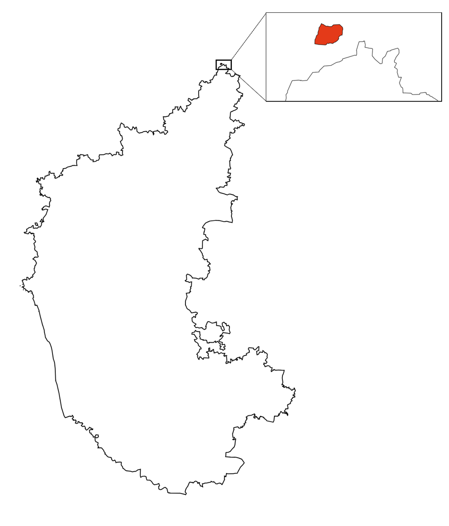
Shifting our focus to Karnataka’s northernmost point, we encounter Chondimukhed, which, as one might expect, is also an enclave within Maharashtra. This village serves as a stark reminder of how these cartographic irregularities negatively impact real people, depriving them of essential resources such as education, job opportunities, and even basic amenities like electricity.5, 6
Others
- Chennakesavapuram, an uninhabited Tamil enclave belonging to Tiruvallur district within Andhra Pradesh’s Chittoor district
- Chhit Bara Laukuthi, a Bengali enclave belonging to Cooch Behar District within Assam’s Dhubri District
- Haryanvi enclave2, belonging to Rewari district within Rajasthan’s Alwar district
- Himachali enclave2, belonging to Solan district within Haryana’s Panchkula district
-
“Animal Kingdoms: Hunting, the Environment, and Power in the Indian Princely States”, Julie E. Hughes, Harvard University Press, 2013. ↩
-
The maps released by the Survey of India show these areas as enclaves, but the maps released by the Directorate of Census Operations do not. ↩ ↩2 ↩3
-
“Sajanpur in Gujarat, but Madhya Pradesh gets its votes!”, Yagnesh Bharat Mehta and Tushar Tere, The Times of India, 25 November 2022. ↩
-
“Centre Discusses Merging of 4 Villages, Piece of Land from Gujarat with Union Territory of Dadra”, Press Trust of India, 16 August 2022. ↩
-
“Karnataka’s northern-most village feels cut off, neglected”, Rakesh Prakash, The Times of India, 12 April 2019. ↩
-
“Two States, and a multitude of problems”, B Rishikesh Bahadurdesai, The Hindu, 30 April 2018. ↩